Every day, the weather somewhere in the world makes headlines, be it through severe weather, new records or extraordinary phenomena. We cover the most significant weather events in detail in our own MeteoBlogs. The other interesting and important weather news are summarized in this Newsflash.
Unusual heat in Africa and America
The fact that it gets hot in Africa is not really unusual. But the range of possibilities is shifting ever higher. In recent days, both the north and south of Africa have been experiencing exceptional heat that exceeds the usual level. As a result, countless records have been broken – and in some cases even pulverized. Not just selectively, but in many countries at the same time. At this point, we once again refer to Maximiliano Herrera, one of the best-known weather and climate statisticians with probably the largest global weather database.
️MOST EXTRAORDINARY EVENT IN CLIMATIC HISTORY
— Extreme Temperatures Around The World (@extremetemps) March 11, 2024
What it's happening today will be remembered for generations
Thousands of records are been brutalized allover Africa from North to South in an area of millions of square kilometers.
No event in world climatic history gets even close. pic.twitter.com/hH84mHjP7O
THOUSANDS RECORDS ALLOVER AFRICA
— Extreme Temperatures Around The World (@extremetemps) March 11, 2024
47.2 South Africa,45.5 Cameroon,45 Niger and Chad,etc...
Records smashed in nearly every single country from North to South from West to East
Never happened anything like this anywhere in the world in climatic history
Most important records pic.twitter.com/UW3MkoSoDu
A similar picture can be seen on the American continent. Important – The graphs do not show absolute temperatures, but the degree of anomaly, i.e. the deviation from the long-term average for this time of year. Taking North America as an example (see below), it was significantly colder than normal in Alaska, for example, but in some cases massively too warm over a much larger area.
After the 46.5 in MEXICO
— Extreme Temperatures Around The World (@extremetemps) March 12, 2024
42 Central America
Heat records in Costa Rica and Panama (38C David all time high)
40 Colombia,
37.6 Lethem GUYANA National record
French GUIANA >35C
40 Caracarai tied HOTTEST DAY IN RORAIMA,BRAZIL
ARGENTINA HIGHEST TMINS
28.8 Las Lomitas, 26.6C Oran
... https://t.co/ci5F6YMFP2
EXCEPTIONAL ARGENTINA 44.5
— Extreme Temperatures Around The World (@extremetemps) March 13, 2024
Very close to the hottest day in March in South America history
Tons of records in Paraguay,Argentina and Bolivia
See below the records of hottest nighs/Days including Cordoba
PARAGUAY
41.2 Pozo Colorado
41 Concepcion,General Bruguez & San Estanislao https://t.co/Q5Ko6QxKQ0 pic.twitter.com/d7z7dlRyG9
Cyclone Filipo
In recent days, Cyclone Filipo has been soaking up moisture over the Mozambique Strait and becoming increasingly structured. Last night, it made landfall in Mozambique with the strength of a category 1 hurricane, but has since weakened and moved its center inland.
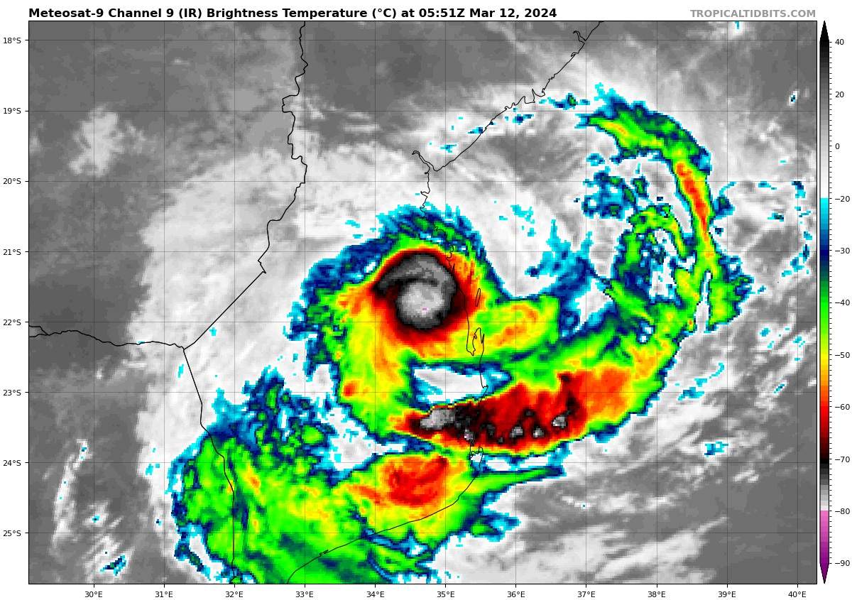
Fig. 1: Infrared satellite image of Cyclone Filipo; Source: tropicaltidbits.com
Filipo will move southwards over land in the coming hours, bringing large amounts of rain. It will reach the coast again tomorrow, Wednesday, and then move out to sea again, where it will intensify once more.
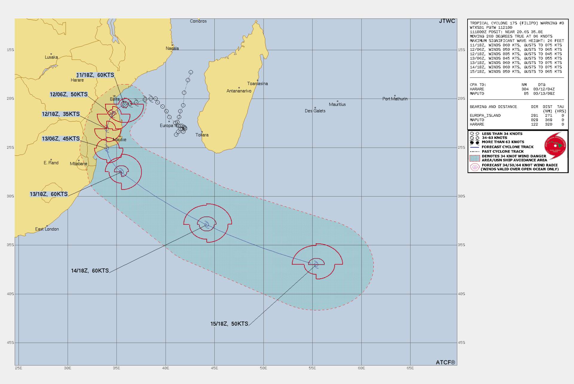
Fig. 2: Further path of storm Filipo; Source: Joint Typhoon Warning Center
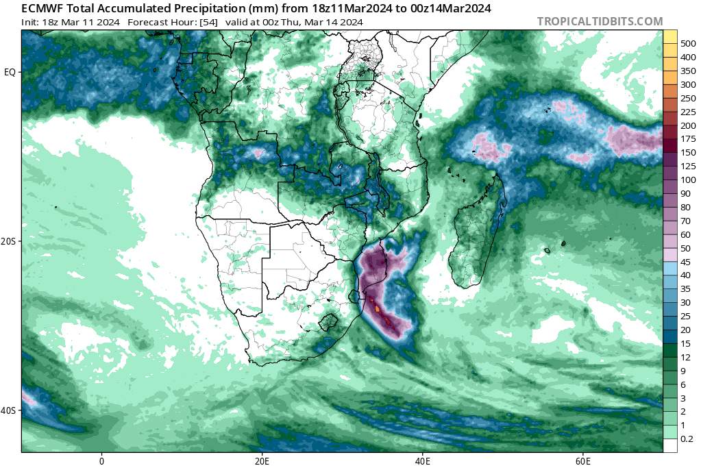
Fig. 3: Accumulated precipitation until March 14, 00 UTC (ECMWF); Source: tropicaltidbits.com
Record warm start to November in many places
New monthly records were set nationally in at least nine countries yesterday and today. So never before has it been so warm on a November day in these countries. The list includes the following states.
- North Korea: 27.3°C
- South Korea: 29.1°C
- Mongolia: 21.8°C
- Bangladesh: 35.8°C
- Philippines: 37.4°C
- Cyprus: 34.3°C
- Malta: 29.1°C
- Tunisia: 36.4°C
- UAE: 38.1°C
In addition to these records, several countries narrowly missed the warmest November day, including Mali, Algeria, Georgia, Nepal, Russia, Dominica and Myanmar.
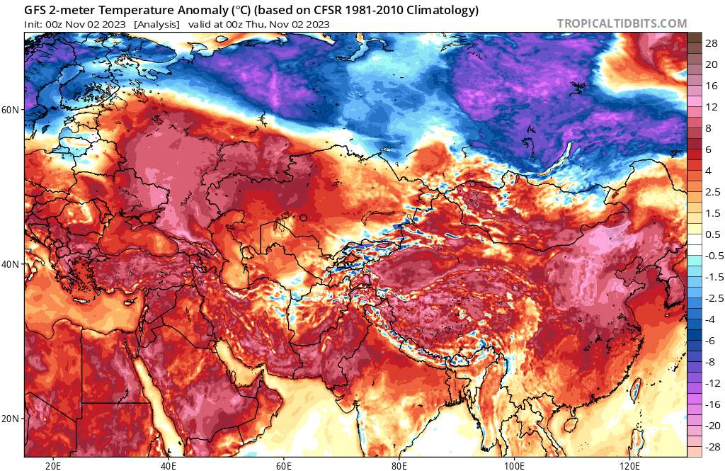
Fig. 1: Temperature Variation in Eurasia; Source: Tropical Tidbits
Hundreds of records in China and Japan
In China alone, there were more than 900 new monthly records yesterday and today, but it wasn't enough for a national record. Also in Japan 122 monthly records fell so far, many more will follow in the coming days! Very impressive was also the minimum temperature of 29.7 degrees (!) in Ekawasaki, a record of the extra class.
The most extreme event in Chinese climatic history:
— Extreme Temperatures Around The World (@extremetemps) November 2, 2023
906 monthly records and 13 provincial records broken in just 2 days.
And this is just the beginning, the heat in the South will just get worse and dozens millions Chinese will need AC this November days. https://t.co/Gc14fX4k4y
Very cold in North America and Northern Europe
North America experienced a very cold start into the new month. At times, temperatures were around 20 degrees below normal, but we are still some distance away from a national record for the month. Also in Scandinavia and Western Europe, the temperature level is currently below normal, but records are not to be registered here either.
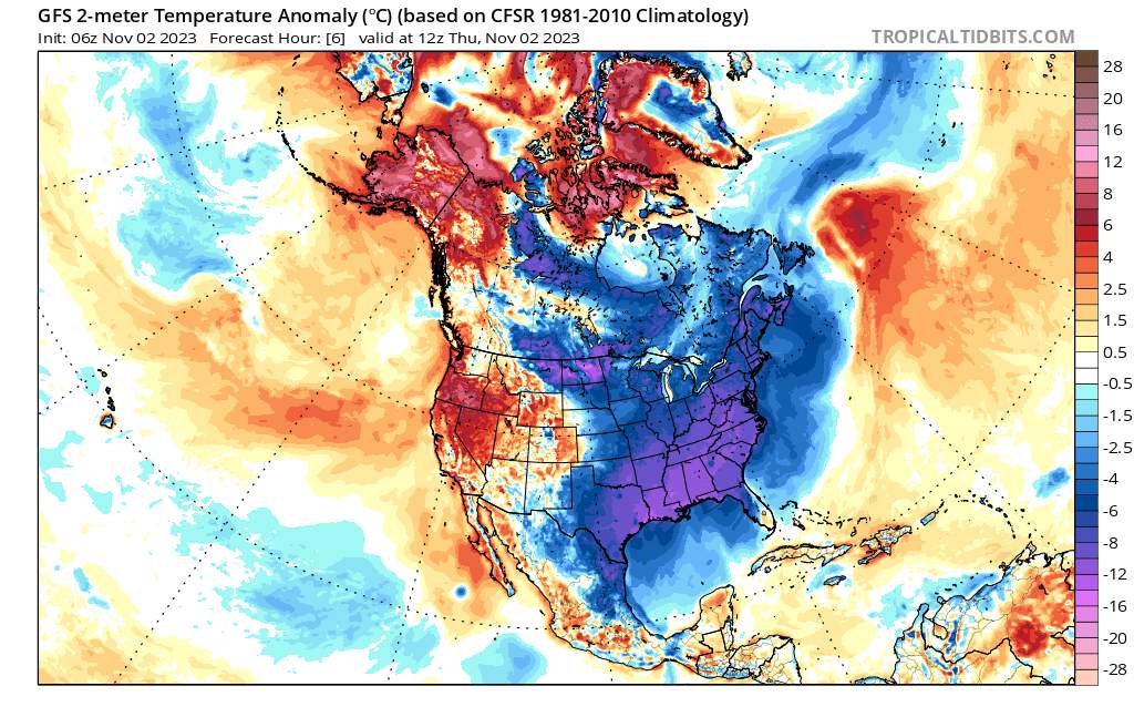
Fig. 2: Temperature deviation North America; Source: Tropical Tidbits
Cyclones Tej, Hamoon and Lola
Currently, there are three tropical cyclones in the Indian Ocean and South Pacific.
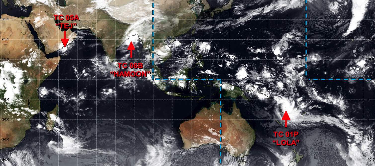
Fig. 1: Overview of current weather patterns in the Indian Ocean and the Northwest and South Pacific Oceans; Source: Joint Typhoon Warning Center
Cyclone Tej has meanwhile reached the Arabian Peninsula and has already weakened in terms of wind. However, it brought and continues to bring enormous amounts of rain to southeastern Yemen and Oman, which borders it to the east. From yesterday to including Wednesday around 500 mm of rain will fall, locally it is even 800 to 1000 mm! For illustration: In al-Ghaida, the capital of the governorate al-Mahra (southeastern Yemen) typically only about 50 mm of rain fall in a year. This event brings together the equivalent of 10 to 20 years within a short period of time. The bone-dry soil cannot possibly absorb these amounts; even much less would be too much. Devastating floods are the result!
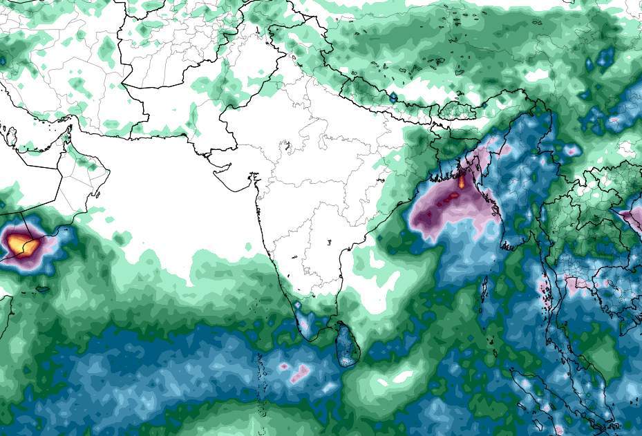
Fig. 2: Accumulated precipitation through 26 October 00 UTC (ECMWF; Source: tropicaltidbits.com
Cyclone Hamoon is currently over the Bay of Bengal, has intensified significantly in the last hours and is moving towards Bangladesh. Also here there are large amounts of rain, in addition the wind in the flat and low-lying coastal area causes a heavy storm surge – it is the actual problem! A humanitarian disaster threatens.
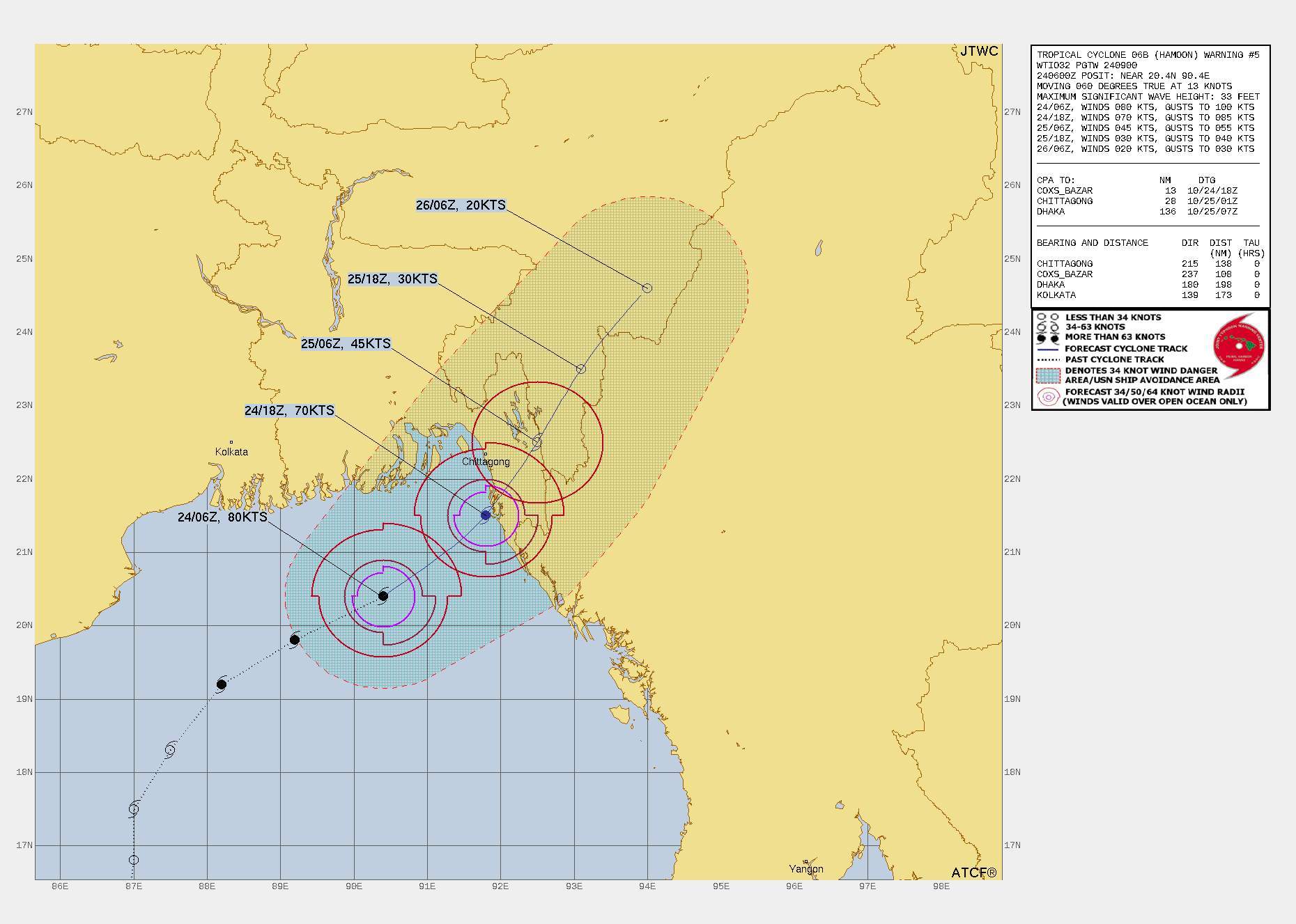
Fig. 3: Cyclone Hamoon track; Source: Joint Typhoon Warning Center
Cyclone Lola is swirling in the South Pacific. It is an exceptionally strong storm and reached the lower category 5, making Lola the strongest storm in 50 years to form so early in the South Pacific cyclone season. It is now located just off Vanuatu. The island nation, which consists of 83 islands, has a population of around 300,000, and major destruction is imminent. The last time this was the case was in 2020 by Cyclone Harold, in 2015 the extremely strong Cyclone Pam destroyed or damaged 90% of the buildings in the capital Port Vila. Due to cyclones, severe earthquakes and active volcanism, Vanuatu is one of the countries most threatened by natural disasters in the world (number 1 in the World Risk Report).
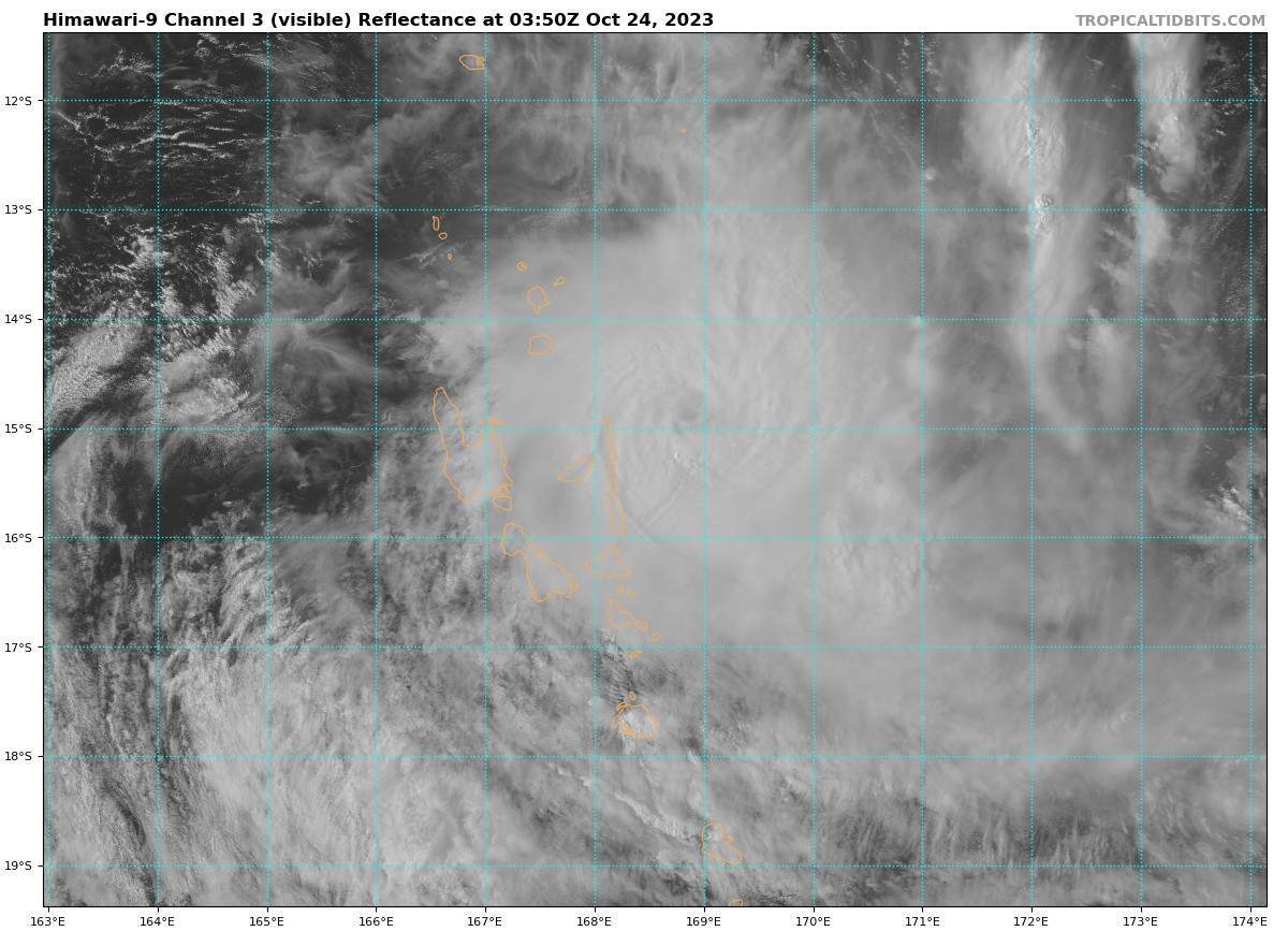
Fig. 4: Satellite image of Cyclone Lola, center just east of Vanuatu; Source: tropicaltidbits.com
Hurricane Lidia hits Mexico
Over the northern eastern Pacific, tropical activity has been fairly quiet for a while. The last tropical storm to reach hurricane status was Jova on September 9. So it took about a month for a tropical system to be upgraded to a hurricane today with Lidia. In the last 50 years or so (since detailed satellite monitoring began in 1970), there have only been three other years that have not recorded a hurricane between September 10 and October 8 (1998, 2002, and 2010).
Currently, Lidia has a mean wind speed of 121 km/h with 1-minute gusts of up to 145 km/h, making it equivalent to a Category 1 hurricane (out of 5) on the Saffir-Simpson scale. The hurricane is expected to strengthen to a Category 2 storm the rest of its path to the Mexican coast. Wind peaks of 200 km/h are not unlikely.
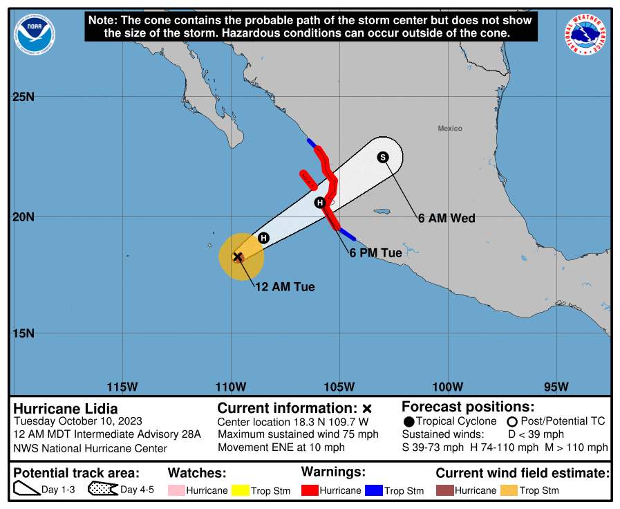
Fig. 1: Predicted train path of Lidia; Source: NWS National Hurricane Center
According to current models, Lidia will make landfall late Tuesday night or Wednesday night (local time) in either the state of Nayarit or Jalisco. The major city around Puerto Vallarta is likely to be particularly in focus.

Fig. 2: First harbingers of Lidia on the coast of Puerto Vallarta; Source: Skyline Webcams
The expected effects of Lidia are multifaceted. In addition to wind and heavy rain, there is also a local risk of flash floods and generally flooded roads. In slightly elevated areas of Nayarit, in the south of Sinaloa and in the coastal areas of Jalisco, debris flows could occur. Storm surges and dangerous currents are also warned near the coast.
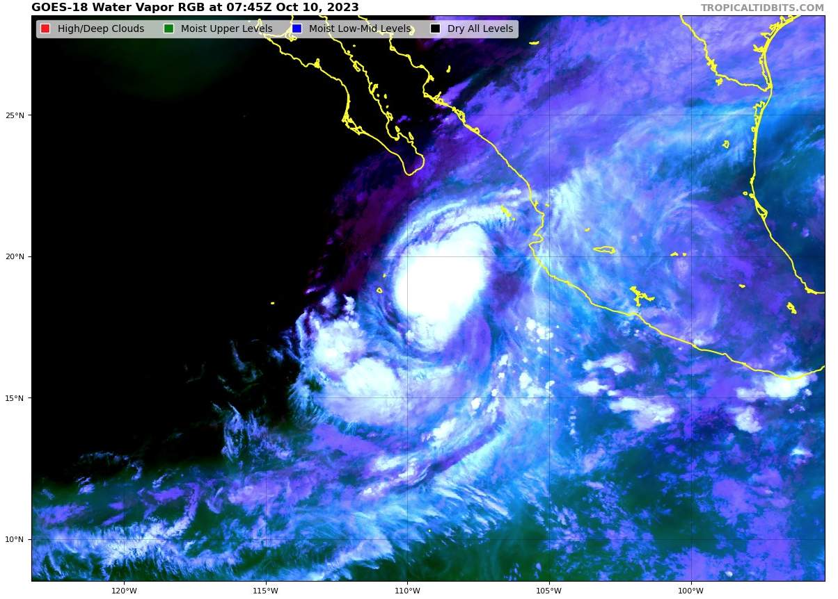
Fig. 3: Lidia over the northern eastern Pacific Ocean; Source: Tropical Tidbits
Large temperature contrasts in Europe
For several days now, there has been an impressive air mass boundary across Europe. This is expressed not only in the degree of cloudiness, but above all in large temperature contrasts. While Western Europe is heading for a record warm first half of October, temperatures in large parts of Scandinavia and Eastern Europe are in part well below the usual seasonal norm.
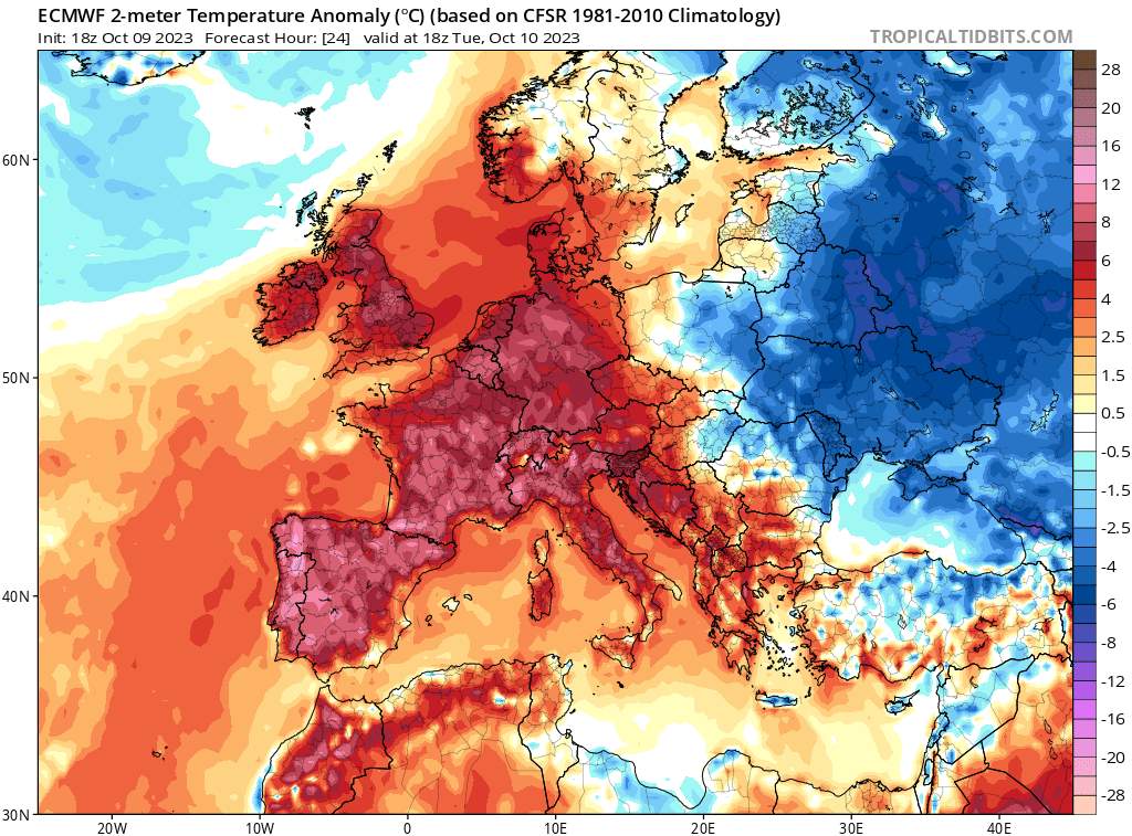
Fig. 1: Temperature deviations from the norm, with red indicating above-average values and blue indicating below-average values; Source: Tropical Tidbits
Below are a few figures that support this contrast. Since the beginning of the month, several hundred (!) monthly records of maximum temperatures or highest daily minima have been set in Central and Western Europe. Some stations have beaten the previous October record several times in the past few days. In Eisenstadt, Austria, the temperature did not drop lower than 21.3 degrees during the night of October 8, a tropical night par exellence and a pulverization of the previous record by more than 4 degrees (17.0 degrees in 1975). In Piedmont, a maximum temperature of 34.5 degrees was measured on the same day, and Slovenia even set a new national October record with 31.3 degrees in Cronomelj. In France, there were no less than 211 new monthly records, with Le Luc being the hottest with 33.9 degrees. Yesterday it continued in a similar style; 146 new October records in France, 28 degrees in Austria(Haiming, Tyrol). The Italian provinces of Piedmont, Lombardy, Emilia, Tuscany and Venice also all set new monthly records at the provincial level.
In contrast, some of the highest values in Eastern Europe were far below average. In Moscow, for example, it should be enough today at a maximum of about 4 degrees even for one or the other snowflake. Normal there at this time of year would be about 10 to 12 degrees. Also in the Ukraine, in Moldavia and Belarus only scarcely double-digit maximum values are registered. That is, 5 degrees and more below normal. These mentioned contrasts over Europe will slowly decrease at the end of the working week, then the "heat bell" will gradually shift to the east.
Daniel also causes flooding in Libya
Last week, Storm Daniel brought extreme amounts of rain to Greece. In recent days, it has moved south across the Mediterranean Sea, taking on tropical characteristics. Yesterday Sunday, the "Medicane" hit Libya, with some large amounts of rain being measured, especially along the coast. In Al Marj, not far from Libya's second largest city Benghazi, 142 mm of rain were recorded within one day. Typically, just 270 mm of rain fall there in a year, with it usually being completely dry between May and September.
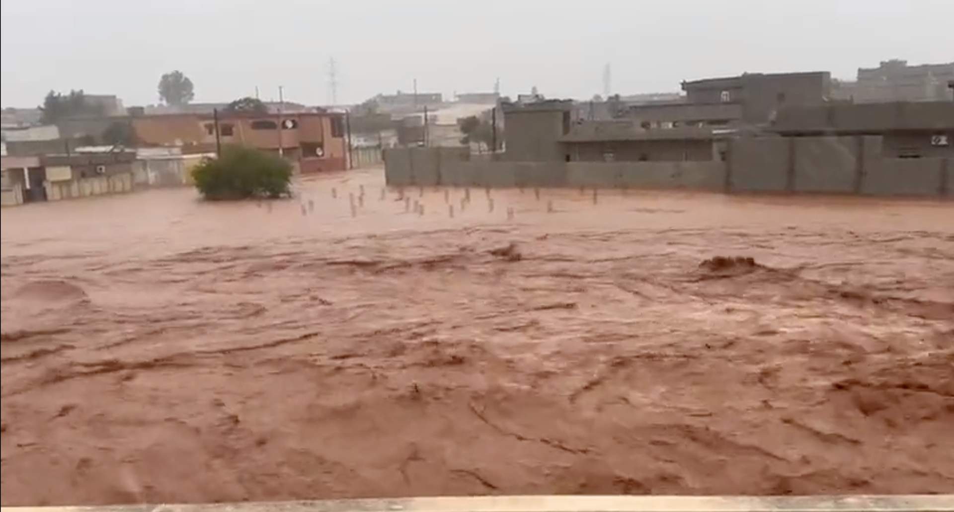
Fig. 1: Floods in Libya ; Source: @ChaudharyParvez via Twitter
In Greece over 750 mm of precipitation so far!
As expected, the storm Daniel in Greece since Monday brought enormous rainfall totals and partly stormy gusts. According to the Greek weather service Meteo, it is one of the strongest storms ever to hit this country. By 8:45 p.m. local time on Tuesday, a daily precipitation total of 754 mm was recorded inZagora in Pilio (Fig. 1), far surpassing the daily precipitation record of 644.7 mm set in Paliki in Kefalonia in September 2020! From midnight tonight to 8:30 am local time,194 mm was recorded at Kofi in Magnisia . For comparison, Athens receives an average of 400 mm of precipitation within an entire year!
However, measured values are missing, since due to the extreme precipitation most weather stations in Magnisia and on the Sporades no longer send data due to a power outage.
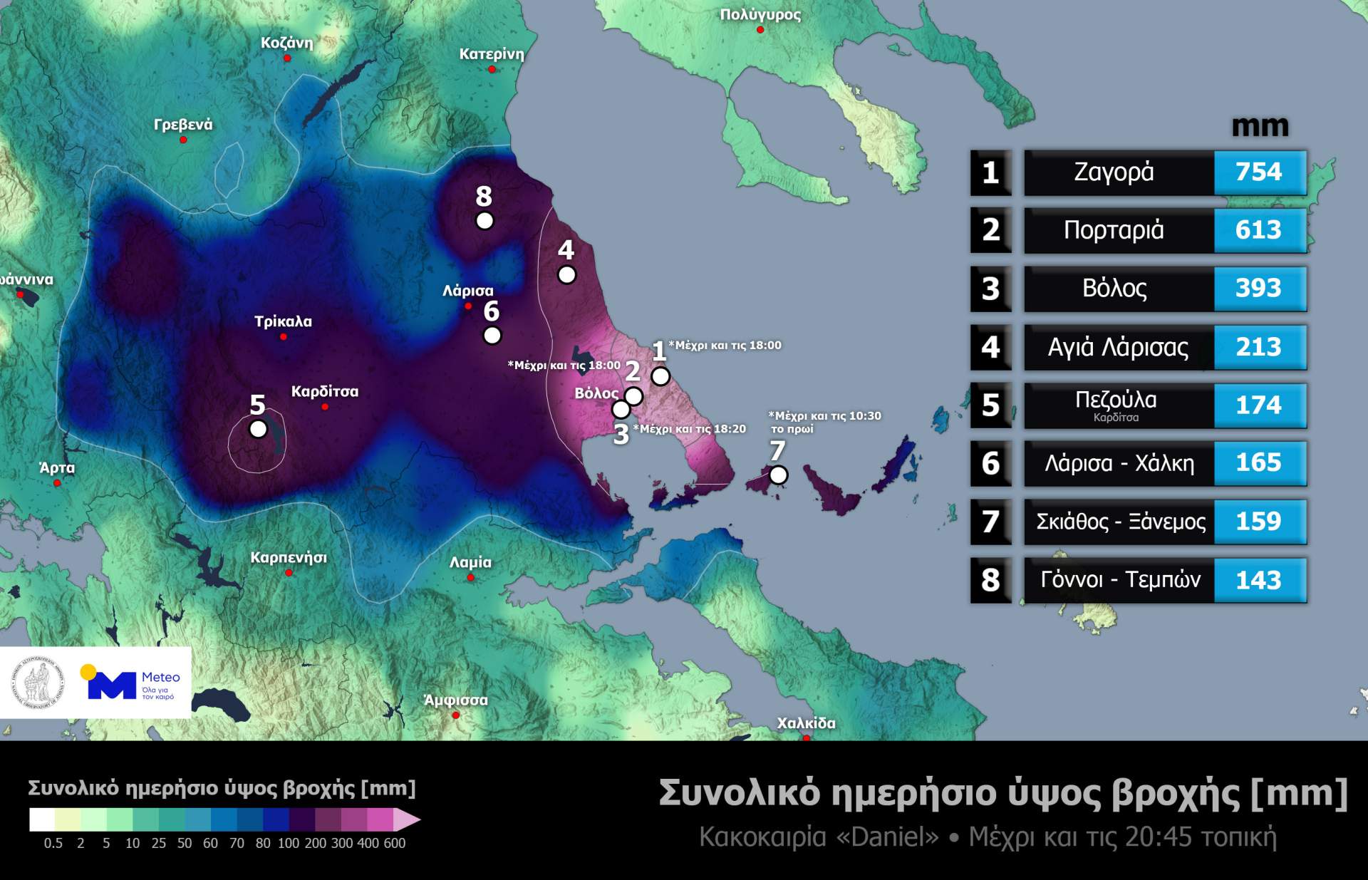
Fig. 1: Daily precipitation total until 20:45 local time. In Zagora 754 mm was registered, due to a power outage some precipitation data are missing.; Source: Meteo
Devastating floods, deaths and severe infrastructure damage have been the result so far. Greece's national weather service warns of intense rainfall and gale-force winds through Thursday. Depending on the model, from 2 a.m. today until 2 a.m. Friday, September 8, up to 300 mm (Fig. 2) are again expected, according to the high-resolution model RACE even 400 to locally 600 mm (Fig. 3)! The situation is expected to calm down until Friday.
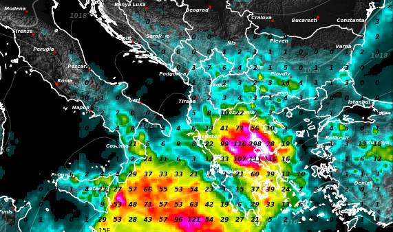
Fig. 2: Precipitation forecast by ECMWF from Wednesday, September 6 2 a.m. to Friday, September 8 2 a.m.. According to this model, up to 300 mm are possible again locally until Friday.; Source: MeteoNews, UBIMET
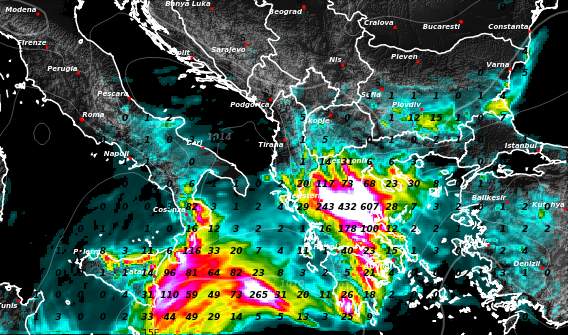
Fig. 3: Precipitation forecast from the high-resolution model RACE from Wednesday, September 6 2 a.m. to Friday, September 8 2 a.m.. According to this model, up to 600 mm are possible again locally until Friday.; Source: MeteoNews, UBIMET
Devastating rains in Greece - great danger of severe weather!
An Omega high has built up over Europe. The name is derived from the Greek letter Omega (the last letter of the Greek alphabet), because it has a similar shape "Ω", as the high, which has inflated like a balloon. The lower approach of the high is flanked by two lows. One of them is over the Atlantic, the other low is between southern Italy and Greece. The latter will bring torrential rains to Greece over the next few days. Individual high-resolution models simulate locally with up to 1000 mm of rain in the period from Monday afternoon (4.9.) and Wednesday evening (6.9.)! Due to these gigantic rain masses in some areas of Greece with devastating floods or landslides must be expected - there is very big danger for life and limb! Especially the region of Thessaly with the capital Larissa should be strongly affected by the storms. Here much points to a true natural disaster! Only marginally affected will be, for example, the capital Athens.
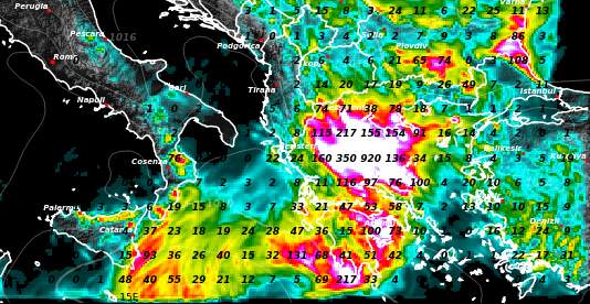
Fig. 1: Precipitation forecast for the period between Monday noon 4.9.2023 and Wednesday evening 6.9.2023 from the high-resolution weather model Race by MeteoNews / UBIMET; Source: MeteoNews AG / UBIMET

Fig. 2: The rain has already started in Thessaloniki. Webcam from Monday afternoon.; Source: Skyline Webcams
Typhoon Saola hits Hong Kong
As a tropical depression, Typhoon Saola has its "birth date" on August 23, 2023. In the days that followed, the storm rapidly developed into a typhoon and looped around in the Pacific east of the Philippines, but has never made direct landfall. On August 29, the super typhoon moved west between the Philippines and Taiwan with winds peaking at over 300 km/h. Now the typhoon is heading for Hong Kong, where it will also arrive in a few hours. The center of the typhoon will pass only a few kilometers south of Hong Kong.
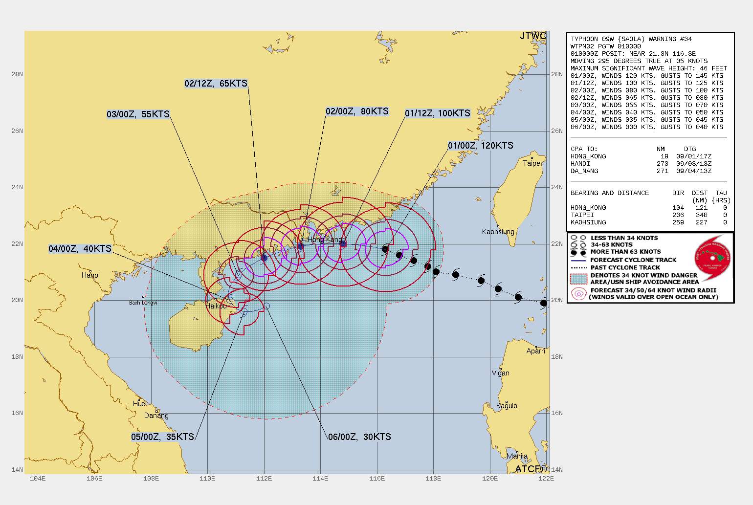
Fig. 1: Forecasted track of Typhoon Saola; Source: JTWC
Thus, uncomfortable hours lie ahead for the nearly 8 million residents in Hong Kong. Even if Typhoon Saola weakens slightly now, wind peaks of 100 to 130 km/h, locally even more, are to be expected in Hong Kong. In addition, locally up to 200 mm of rain will fall in 2 days. Also strongly affected will be the region of Macau and other cities along the coast to Zhanjiang. However, the typhoon will also weaken further over the weekend.
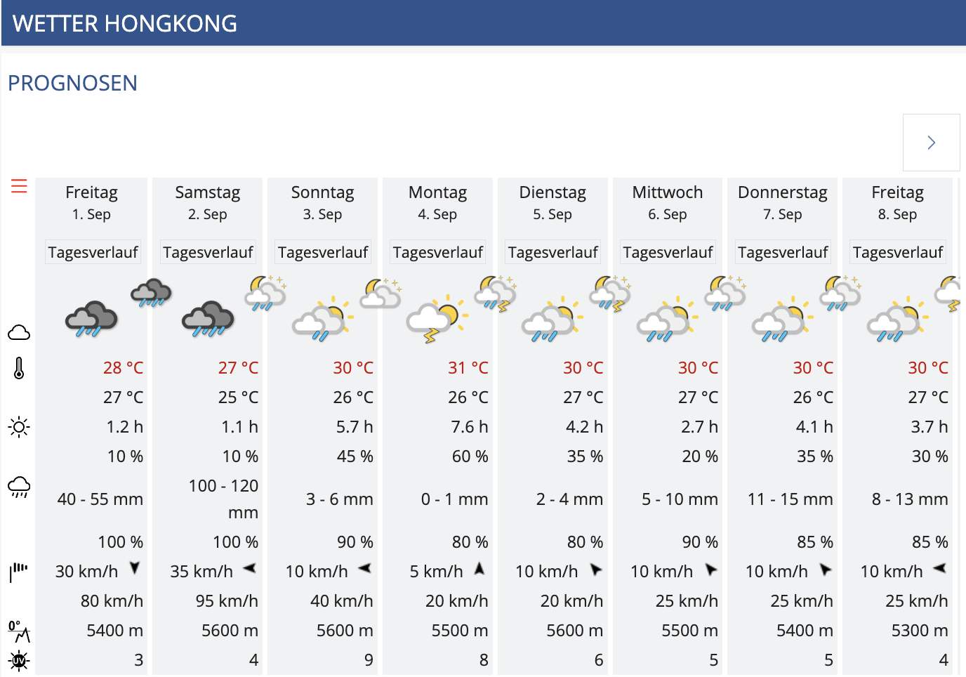
Fig. 2: On Friday and Saturday, Typhoon Saola will bring massive rainfall and wind peaks of 100 to 130 km/h to Hong Kong.; Source: MeteoNews AG
Over 43 degrees in France - new records
In France today, on this August 23, 2023, five official measuring stations measured 43 degrees or more. Puy-Saint-Martin was the hottest with 43.5 degrees, followed by Salindres with 43.3 degrees. Various new monthly and all-time records were thus broken. In Orange, for example, the previous maximum temperature was exceeded by 0.1 degrees. The previous record from the century-hot summer of 2003 was 42.6 degrees.
An overview of the official measuring stations in France that measured over 42 degrees today is shown in the following hit list. Tomorrow Wednesday and also on Thursday there will be again 40 degrees and more in various places in southern France – the heat wave still continues!
Highest temperature (as of 20:54)
| Measuring stations | Highest temperature (in °C) |
|---|---|
| Puy-Saint-Martin | 43.5 |
| Salindres | 43.3 |
| Moulès-et-Baucels | 43.2 |
| Grospierres | 43.0 |
| Siran | 43.0 |
| Orange | 42.7 |
| Saint-Christol-lès-Alès | 42.7 |
| Cardet | 42.6 |
| Saint-Barthélemy-de-Vals | 42.5 |
| Uzès | 42.5 |
| Durban-Corbières | 42.5 |
| Argeliers | 42.4 |
| Lapalud | 42.4 |
| Soumont | 42.3 |
| Cadenet | 42.3 |
| Montségur-sur-Lauzon | 42.2 |
| Vinsobres | 42.2 |
| Carpentras | 42.2 |
| Lagrasse | 42.2 |
| Générargues | 42.2 |
Rain record in "Death Valley"
Death Valley is located in the Mojave Desert in the west of the USA. The largest part lies in the US state of California. The region is very dry, rain falls here only on a few days a year. Over the whole year there are about 30 rainy days and about 120 mm of rain. Yesterday, August 20, 2023, 55.88 mm of rain fell within one day, more than ever before on a single day since measurements were taken in 1911, as the National Weather Service NOAA writes on X.
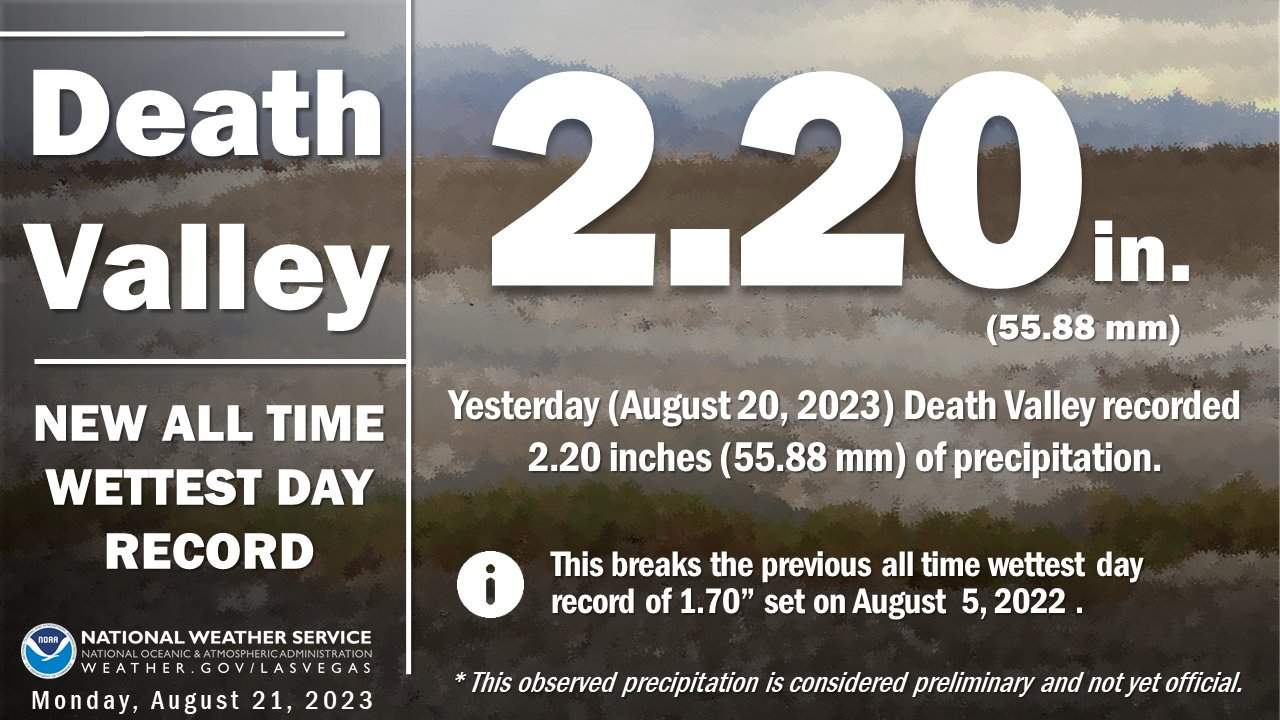
Fig. 1: New record for daily precipitation in Death Valley; Source: NWSVegas
disclaimer
The content of this article has been at least partially computer translated from another language. Therefore, grammatical errors or inaccuracies are possible. Please note that the original language version of the article should be considered authoritative.

