After today's rather unsettled Thursday, a ridge of high pressure will provide Switzerland with plenty of sunshine and exceptionally high temperatures for the time of year from tomorrow Friday to Monday. The high pressure current will turn from west to southwest, bringing in warm subtropical air, especially at the weekend and on Monday. Some temperature records are likely to be set for the first half of April, and absolute April records cannot be ruled out locally, especially at high altitudes. On Tuesday, a cold front moving in from the west will bring the exceptionally warm weather phase to an end.

Another summer day to start the week
As expected, the summer mark of 25 degrees was also broken today (Monday) at various stations. The highest temperatures were measured in the Alpine valleys with foehn support. Oberriet topped the list with 27.8 degrees, followed only slightly behind by Vaduz and Giswil with 27.7 degrees each.
Highest temperature (as of 16:50)
These temperatures are around 10 to 12 degrees above the norm and are more in line with early June than early April.
Various records on Sunday
We have already reported on the highest temperatures on Sunday. However, we would like to add a few new monthly records for the highest daily minimums (i.e. the temperatures that did not fall below the norm throughout the day).
| Station | Yesterday's minimum (°C) | previous record (°C) |
| Weissfluhjoch | 6.1 | 4.8 |
| Arosa | 8.7 | 8.6 |
| Gütsch | 5.9 | 5.5 |
| Moléson | 12.2 | 11.0 |
| Bullet / La Frétaz | 13.7 | 11.9 |
| La Brévine | 9.2 | 9.2 |
| Chasseral | 12.2 | 12.0 |
| Grand St. Bernard | 5.2 | 3.5 |
| La Chaux-de-Fonds | 12.2 | 11.1 |
| Piz Corvatsch | 1.3 | 0.3 |
The deviation of the average daily temperature from the norm was 10 degrees on average.

Fig. 1: Temperature deviation from the norm; Source: MeteoNews/Ubimet
The desert greets us again
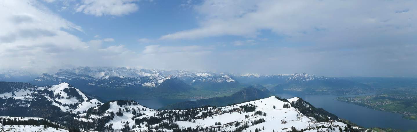
There was already quite a bit of Sahara dust in the air today, the sunlight was "dimmed" and visibility at altitude was sometimes quite cloudy (see Fig. 1 & 2).

Fig. 1: The view on the Niederhorn was clouded by Sahara dust today, Sunday; Source: Roundshot

Fig. 2: The view at the Männlichen mountain station was also hazy; Source: Roundshot
With the partly dense veil clouds, it was less warm today compared to yesterday, only enough for a summer day in places. This was the case, for example, in Basel-Binningen with 26.2 degrees and in Chur with 26.1 degrees (see Fig. 3 and table below). Nevertheless, it was enough for an April record: on Piz Corvatsch today, at 4.3 degrees, yesterday's new record was already exceeded by 0.2 degrees. In La Brévine, the April record from 2018 was equaled at 22.8 degrees.

Fig. 3: Maximum temperature today, Sunday, April 7 until 4 p.m.; Source: Roundshot
Highest temperature (<1000m, as of 16:50)
| Lowland stations | Highest temperature (in °C) |
|---|---|
| Basel-Binningen | 26.2 |
| Chur | 26.1 |
| Delémont | 25.9 |
| Aigle | 25.3 |
| Bad Ragaz | 25.0 |
| Vaduz | 24.9 |
| Visp | 24.6 |
| Altdorf | 24.5 |
| Sion | 24.4 |
| Glion | 24.2 |
| Courtelary | 24.1 |
| Schiers | 24.1 |
| Bern-Belpmoos | 24.0 |
| Evionnaz | 24.0 |
| Koppigen | 23.9 |
| Mühleberg | 23.9 |
| Beznau | 23.8 |
| Oberriet | 23.8 |
| Würenlingen | 23.7 |
| Gösgen | 23.6 |
Highest temperature (>1000m, as of 16:50)
| Mountain stations | Highest temperature (in °C) |
|---|---|
| La Chaux-de-Fonds | 22.8 |
| La Brévine | 22.8 |
| Engelberg | 22.5 |
| Les Charbonnières | 22.4 |
| Scuol | 22.2 |
| Château-d'Oex | 22.0 |
| Adelboden | 21.7 |
| Robbia | 21.5 |
| Vicosoprano | 20.9 |
| Plaffeien | 20.4 |
| Col des Mosses | 20.3 |
| Piotta | 20.2 |
| Mustér | 20.1 |
| Santa Maria Val Müstair | 20.0 |
| Bravuogn | 19.9 |
| Hörnli | 19.8 |
| Vals | 19.6 |
| La Frétaz | 19.4 |
| Crans-Montana | 19.4 |
| Chaumont | 19.2 |
Tomorrow, Monday, it will be warm again in early summer, with temperatures close to the absolute April records possible in the foehn valleys. The southerly foehn will gain more and more strength here on Monday and blow strongly towards Monday evening and during the night into Tuesday (more on this in the warnings). On Monday, for example, around 26 to 28 degrees are expected in the Rhine Valley, with local temperatures of around 29 degrees not out of the question.
Saturday: Warmest day in the north so far in 2024
Today, Saturday, was by far the warmest day in the north so far this year. It was warmest in Basel-Binningen with a south-easterly wind at 28.8 degrees, followed by Chur with 28.5 degrees (see table below).
Highest temperature (as of 16:40)
| Measuring stations | Highest temperature (in °C) |
|---|---|
| Basel-Binningen (316 a.s.l., BL) | 28.8 |
| Chur (555 a.s.l., GR) | 28.5 |
| Delémont (439 a.s.l., JU) | 27.7 |
| Bad Ragaz (496 a.s.l., SG) | 27.4 |
| Sion (482 a.s.l., VS) | 27.3 |
| Fahy (596 a.s.l., JU) | 26.3 |
| Visp (640 a.s.l., VS) | 26.3 |
| Glion (774 a.s.l., GR) | 26.3 |
| Schiers (660 a.s.l., GR) | 26.2 |
| Vaduz (460 a.s.l.) | 26.1 |
| Würenlingen (334 a.s.l., AG) | 26.0 |
| Leibstadt (341 a.s.l., AG) | 26.0 |
| Beznau (325 a.s.l., AG) | 25.9 |
| Ebnat-Kappel (620 a.s.l., SG) | 25.9 |
| Tänikon (536 a.s.l., TG) | 25.8 |
| Boltigen (820 a.s.l., BE) | 25.8 |
| Zurich Airport (436 a.s.l., ZH) | 25.3 |
| St. Chrischona (493 a.s.l., BS) | 25.2 |
| Schaffhausen (438 a.s.l., SH) | 25.1 |
| Buchs-Aarau (387 a.s.l., AG) | 25.1 |
New absolute April records locally
Locally, it was warmer today than ever before in April. New absolute April records were set, for example, in Chur with 28.5 degrees (previous record 27.7 degrees, measurements from 1959), Fahy with 25.6 degrees (previous record 25.3 degrees, measurements from 1981), Adelboden with 22.4 degrees (previous record 21.9 degrees, measurements from 1966) and the Weissfluhjoch with 8.7 degrees (previous record 7.8 degrees, measurements from 1971). In addition, there are many records for the first half of April, especially at high altitudes.
Sunday/Monday similarly warm
Tomorrow, Sunday, similar or even slightly higher maximums are likely to be reached, and further absolute April records are possible locally. Monday will also be exceptionally warm again, although there will be a lot of Saharan dust, which could dampen the maximums somewhat. However, maximums close to the absolute April records are possible again, especially in the Föhn valleys.
Friday: Only just missing the summer mark!
The summer mark of 25 degrees was only just missed today, with local temperatures above 24 degrees (see table below). This made today the warmest day of the year in many places in the north.
Highest temperature (as of 16:50)
| Measuring stations | Highest temperature (in °C) |
|---|---|
| Sion (482 a.s.l., VS) | 24.7 |
| Oberriet (420 a.s.l., SG) | 24.4 |
| Vaduz (460 a.s.l.) | 24.4 |
| Basel-Binningen (316 a.s.l., BL) | 24.2 |
| Beznau (325 a.s.l., AG) | 24.2 |
| Möhlin (308 a.s.l., AG) | 23.7 |
| Chur (555 a.s.l., GR) | 23.7 |
| Würenlingen (334 a.s.l., AG) | 23.6 |
| Geneva (420 a.s.l., GE) | 23.6 |
| Bad Ragaz (496 a.s.l., SG) | 23.5 |
| Schaffhausen (438 a.s.l., SH) | 23.4 |
| Leibstadt (341 a.s.l., AG) | 23.4 |
| Delémont (439 a.s.l., JU) | 23.3 |
| Zurich Airport (436 a.s.l., ZH) | 23.3 |
| Altdorf (449 a.s.l., UR) | 23.3 |
| Güttingen (440 a.s.l., TG) | 23.2 |
| Bern-Belpmoos (510 a.s.l., BE) | 23.0 |
| Zurich-Reckenholz (443 a.s.l., ZH) | 22.8 |
| Buchs-Aarau (387 a.s.l., AG) | 22.7 |
| Wädenswil (463 a.s.l., ZH) | 22.7 |
Tomorrow, Saturday, will be even warmer, with the summer mark of 25 degrees being at least partially reached and exceeded in the north, with local temperatures reaching 28 degrees.
Still unsettled in the north today, Thursday
This morning will be mostly dry, with some sunshine between the dense clouds. During the afternoon, there will be heavy clouds with a few showers, especially on the northern edge, with the snow line at over 2000 meters. The clouds will clear again towards the evening. With a moderate south-westerly wind, temperatures will reach a mild 16 to 18 degrees, with the zero degree line rising to 2500 meters. In the south, it will remain dry with quite sunny weather all day and temperatures similar to those in the north (see Fig. 1).

Fig. 1: Weather today Thursday; Source: MeteoNews
Quite sunny from tomorrow Friday to Monday, local record temperatures for April possible
In the run-up to a trough over the Atlantic, a ridge of high pressure will be installed over the Alpine region from tomorrow Friday until next Monday, bringing air masses of subtropical origin to us. The weather models expect temperatures of around 15 to 18 degrees from Saturday to Monday at around 1500 meters, which is exceptionally mild for the time of year. The zero degree line will be at around 4000 meters at the weekend, when the air mass is at its mildest. In addition, apart from a few hazy clouds, the weather will be quite sunny.
The exact temperature level is modeled somewhat differently in the various models, but the air mass itself would provide a lot, in any case, especially at the weekend, sometimes summery 25 degrees and just over. However, there will be a lack of mixing in the lowlands as it will only be lightly windy. The nights are still quite long, which means that the air can still cool down quite a bit and a lake of cold air can form. It is questionable whether this can be completely cleared out during the day, as temperatures could be slightly lower than modeled. This does not apply to the often foehn-laden Alpine valleys, where the foehn ensures good mixing and therefore often slightly higher temperatures compared to the swiss plateau. In addition, there will be a lot of Saharan dust in the air, especially on Sunday and Monday, which will make visibility hazy and promote the formation of high clouds (see Fig. 2, more about Saharan dust tomorrow). This could also dampen temperatures somewhat.

Fig. 2: There is also a lot of Sahara dust in the air again, especially on Sunday and at the beginning of the week; Source: University of Athens, SKIRON
This is why the following table, which shows the record values for the first half of April and the whole of April for a few selected stations, also shows a fairly wide range of expected values. Depending on the situation, there may be records for the first half of April or, especially in the mountains, locally for the whole of April.
| Station | Record first half of April | Absolute April record | Expected max. SA-MO | 1st summer day (max. > 25°C) | Data since |
| Zürichberg | 25.1°C (2007) | 28.8°C (1934) | 23-26°C | 14.4. 2007 | 1881 |
| Bern | 25.3°C (1904) | 28.2°C (2012) | 22-25°C | 15.4. 1904 | 1864 |
| Basel | 26.9°C (1904) | 29.4°C (1934) | 24-28°C | 30.3. 1989 | 1897 |
| Geneva | 27.7°C (1904) | 27.7°C (1934) | 23-27°C | 8.4. 1961 | 1864 |
| Sion | 26.8°C (2011) | 28.6°C (1968) | 24-28°C | 2.4. 2011 | 1958 |
| Lugano | 31.6°C (2011) | 31.6°C (2011) | 22-24°C | 9.3. 2000 | 1864 |
| Chur | 26.4°C (2007) | 27.7°C (1968) | 25-27°C | 2.4. 2011 | 1959 |
| St. Gallen | 22.5°C (1961) | 26.0°C (2012) | 22-24°C | 28.4. 2012 | 1959 |
| Lucerne | 26.2°C (1934) | 29.1°C (2012) | 24-26°C | 7.4. 2011 | 1886 |
| Davos | 19.0°C (2011) | 19.4°C (2012) | 18-21°C | - | 1889 |
| Säntis | 8.3°C (2007) | 10.6°C (1934) | 8-11°C | - | 1901 |
Tab. 1: Expected maximum temperatures from Saturday to Monday compared to the record values for the first half of April and the whole of April as well as the date of the first summer day
Cooling on Tuesday with a cold front from the west
In the course of Tuesday, a cold front moving in from the west is expected to end the exceptionally warm weather phase, although the exact timing is still unclear. On Wednesday, temperatures will probably only be around 10 degrees in unsettled weather.
Fig. 3 shows the approximate weather and temperature development from tomorrow Friday to next Wednesday.

Fig. 3: Weather outlook from Friday to Wednesday; Source: MeteoNews
disclaimer
The content of this article has been at least partially computer translated from another language. Therefore, grammatical errors or inaccuracies are possible. Please note that the original language version of the article should be considered authoritative.