In recent weeks, our weather has often shown the changeable and repeatedly wet side. After a relatively dry winter, the water balance has been improved. But what exactly is the current situation?

Dry and low snow winter
Overall, the winter of 2022/23 was too warm and too dry. The Alpine region and southern Switzerland were particularly poor in precipitation. Here, the precipitation deficit over the three months was around 50%. As a result, snow depths were also well below the long-term average, with only about 30-50% of the usual snow amounts in many places at the beginning of February. The omens for another devastating summer half-year for the glaciers were thus definitely given. We remember, last year alone the Swiss glaciers lost about 6% of their total volume – a sad record.
Some relaxation in spring
Compared to last year, this year's spring was, to the chagrin of many, much more positive for the water balance (more on this in the recently written spring balance). On the one hand, there was an above-average amount of rain or even snow in the Alpine region (except in the mountains of Ticino) and also in German-speaking Switzerland; throughout Switzerland, a surplus of about 20% can be expected. On the other hand, the average temperature was slightly above normal, but about 1.5 degrees lower than last year's spring.
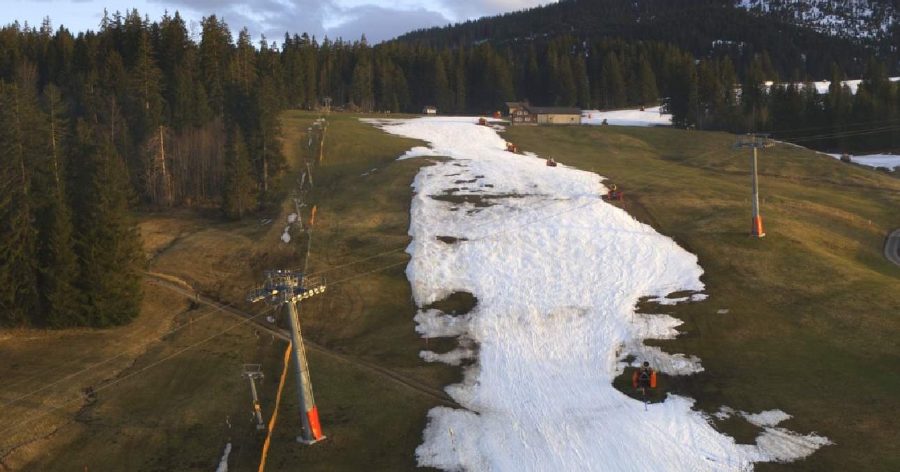
 and 2023 (bottom)")
Fig. 1: Glacier 3000 on May 23, 2022 (top) and 2023 (bottom). Not only the construction crane is different compared between the years.; Source: Roundshot
According to a research group from WSL (Swiss Federal Institute for Forest, Snow and Landscape Research), which specializes in drought, the situation in the Swiss mountains is better than a year ago, but regionally there is still some snow deficit. The deficit is typically expressed in snow water equivalent (mm). This measure describes how much water is missing in the form of snow and is thus more robust than pure snow depth (since different snow densities limit comparability here). Looking at these values, there are deviations of about 150 to locally almost 250 mm, especially for the southern part of the Alps, from the Simplon to the Upper Engadine. The situation is more balanced in the rest of the Alpine region, where largely balanced or only slightly negative balances can be identified. In the Valais Alps, there is currently even a slight surplus.
Hydrological year in long-term comparison
These findings can also be confirmed with the precipitation fallen in the current hydrological year. Unlike the calendar year, the hydrological year in Switzerland begins on October 1 and lasts until September 30 of the following year. This definition was established this way because typically the end of September is when there is the least snow in the Alps, and thus the amount of "bound" water is the lowest. For example, if the calendar year were chosen as the hydrological year, snowfall from December would be credited to the following year due to delayed melting. A dry December, on the other hand, "brings" little meltwater into the following year –. According to this calculation method, the fluctuations between the individual years would therefore be very large, depending on the previous history.
Broken down to numbers, the following compilation results for the current hydrological year.
| Station | Norm 1981-2010 (Oct. 1 - May 23) | previous hydrological year (Oct. 1, 2022 - May 23, 2023) |
| Basel | ≈ 450 mm | 417 mm |
| Bern | ≈ 590 mm | 604 mm |
| Davos | ≈ 500 mm | 466 mm |
| Geneva | ≈ 580 mm | 526 mm |
| Lugano | ≈ 800 mm | 633 mm |
| Lucerne | ≈ 590 mm | 680 mm |
| Sion | ≈ 380 mm | 478 mm |
| St. Gallen | ≈ 670 mm | 839 mm |
| Zurich | ≈ 600 mm | 630 mm |
While central and eastern Switzerland received above-average amounts of rain or even snow, the balances on the Central Plateau are quite balanced. In the south, the partly abundant precipitation in the third decade of April only mitigated the deficit to a certain extent; in a long-term comparison, there is still quite a bit missing for a balanced balance.
Often inconspicuous lake levels
After Lake Lucerne briefly reached the 2nd danger level (out of 5) on May 11 due to repeated and partly heavy rainfall, the level has since returned to normal. Compared to the last two years, it is now even a few centimeters lower (see table). A selection of other lakes shows no major anomalies compared to previous years. The exceptions are Lake Constance and Lake Zug. Both show significantly higher water levels than in previous years and are 15 centimeters (Lake Constance) and around 40 centimeters (Lake Zug) above the norm.
The water levels in the following lakes are given in meters above sea level.
| Water levels of selected lakes (May 23) | 2023 | 2022 | 2021 | 2020 | 2019 |
| Lake Constance (Obersee – Romanshorn) | 396.14 | 395.69 | 395.92 | 395.65 | 396.19 |
| Lake Geneva (Geneva, Sécheron) | 372.04 | 372.02 | 372.21 | 371.91 | 371.98 |
| Lake Lucerne | 433.68 | 433.76 | 433.72 | 433.62 | 433.81 |
| Lake Zurich | 406.03 | 406.00 | 406.05 | 405.97 | 406.13 |
| Lake Zug | 413.97 | 413.36 | 413.67 | 413.43 | 413.75 |
Well filled reservoirs
Once a week, the Swiss Federal Office of Energy (SFOE) publishes figures on reservoir levels. Typically, reservoirs fill up in spring due to increasing snowmelt. Currently, the average fill level of all monitored reservoirs is 32%; from 2013 to 2021, the average level at this time was about 20%. Again, a similar geographic distribution as for the snow water equivalent can be seen. In Graubünden, reservoirs are filled to an average of 41%, while in Ticino they are only 21% full, although this value is also slightly above the long-term average. In Valais, too, the lakes are relatively well filled (24% compared to about 12% in the long-term average).

Fig. 2: Level of the reservoirs in Switzerland; Source: Bundesamt für Energie
What does this mean now?
First and foremost, it can be stated that the repeated precipitation in April and May has led to a certain easing of the drought in Switzerland, even if there are still regional differences. Due to the partly low snow line in the past weeks, the Alpine region now also has a larger bound water volume. The glaciers are also somewhat better protected by the snow cover than was the case last year. This is of course a snapshot, but as of now we are relatively well prepared for the summer months, which from a meteorological point of view start on June 1. Whether we will not have any water problems in the summer, however, cannot be said at this point in time. Repeated stable weather conditions can quickly make us forget the current rather changeable weather.
disclaimer
The content of this article has been at least partially computer translated from another language. Therefore, grammatical errors or inaccuracies are possible. Please note that the original language version of the article should be considered authoritative.